Arctic Tracker / Figures / arctic-definition
Figure 1, Arctic zones; Arctic areas covered by Russia
How this page was produced derived
Read from figure_provenance.json, generated by the pipeline that produces the figures and copied here byte for byte at commit 70da249, generated 2026-10-21. The copy fails rather than completes if any artifact it names is missing. Nothing on this page is authored in this application.
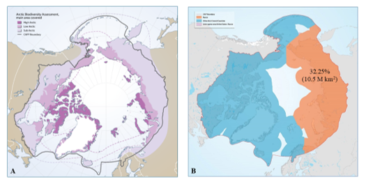
arctic-definition · no binding established
Binding evidence, as the record states it: NO BINDING ESTABLISHED. Cartographic figure. No scripted pipeline exists in the repository.
Why there is nothing to download for this figure. It is a cartographic figure: a drawing that explains a structure, not a plot of the data. No number in it was computed from the dataset, so there is no source file, no processing chain to trace and nothing to regenerate. That is its finished state, not a gap. What this page can vouch for is below: that no generative model made it.
LLM involvement: none. No generative model produced this figure.
Validation: not applicable. There is no numeric output to verify against a database.